Toward the end of our stay at Agua Verde, Ashek and I were chatting with Kirby and comparing notes on where we might be headed next.
Val and I have learned in our travels that our single best resource when solving for the “what do we do next” problem is other travelers.
The more grizzled the beard, the deeper the tan, the shaggier the mane, the more interested we are in talking to you about where you have been and where you’d go if you were us. We routinely find folks down here who have been visiting the peninsula for two, three and four decades and have yet to have taken advice from them and been disappointed.
We therefore absolutely pounced on Kirby, a Baja veteran of over 30 years, and got him to not only demonstrate how to make tortillas to us, but hauled out our topographic map and started pelting him with questions about what to do next.
We intended to keep heading south, but south of Agua Verde there were simply no more roads along the coast, so our travels would necessarily take us inland and across the peninsula on Mexico 1 to the Pacific side, where we’d be able to resupply at Ciudad Constitucion before taking our next leg down.
Kirby pored over the map and his finger settled on a dot on the Sea of Cortez side, reachable only by a series of ever-deteriorating roads that made their way through some of the most mountainous terrain in the region, annotated as “Los Dolores”.
“I haven’t been there in a long time, but there’s an old mission there, and a spring as well, and there’s a grove of fig and mango trees that the missionaries planted a long time ago. But be careful,” he paused, moving his finger to indicate the road that led to Los Dolores, “because that road isn’t a road. There is no road there at all.”
Ashek and I, looking at the map later on that day, noted the significant challenge in getting to and finding this place. Further, a web of smallish roads led south and east away from Los Dolores, and appeared to spit us out just below San Evaristo, a small fishing village where the coastal road north from La Paz stops. If we made it out of the hills to San Evaristo, we could drive south along the coast two or three hours on gravel roads that would take us to La Paz where we could ultimately resupply.
Doing a little further research, we noted that several years ago an Overland Journal article on travel in Baja contained the following information: “If a serious overland trek is on the agenda, the remote, rugged route to San Evaristo—though difficult to locate—is one of the best on the peninsula. The track, which winds its way through washouts, loose climbs and narrow shelf roads, is best suited for the experienced Baja traveler.”
So, arcane and dangerous, with a high likelihood of getting lost. Ashek and I arched eyebrows at each other, conspiratorially. Perfect, we agreed.
***
We stayed on at Agua Verde a few days longer than Ashek and Alex, as poor Alex had been combatting a tenacious bug and they wanted to get to Ciudad Constitucion to enlist the help of a doctor and pharmacy.
We finally caught up with them at the Oasis Hotel, which was frankly extravagant relative to our prior string of accommodations – there was a pool, hot showers, a lovely, spacious room, and a courtyard that was well-shaded and had a reasonable internet connection, permitting the modern miracle of “Skype with the Grandparents” to take place.
Alex was, mercifully, on the mend, and after a day spent stuffing the truck with provisions thanks to the local Super Ley, Ashek and I sat down and accomplished two things: we cleaned ourselves up (I took out the clippers my father in law had given me back in Tucson and took my beard down a notch, and Ashek reigned in his rogue hair) and planned our journey.
For Val and myself, planning a trip has typically involved locating where we want to go on a map, and hoping we can make it in a day. I was thus in awe of the near-surgical precision that Ashek brought to planning, using a satellite map he had pre-loaded into his iPad, a GPS unit, and the analog paper map to confirm the existence of roads, towns, and plot waypoints en route to prevent serious disasters.
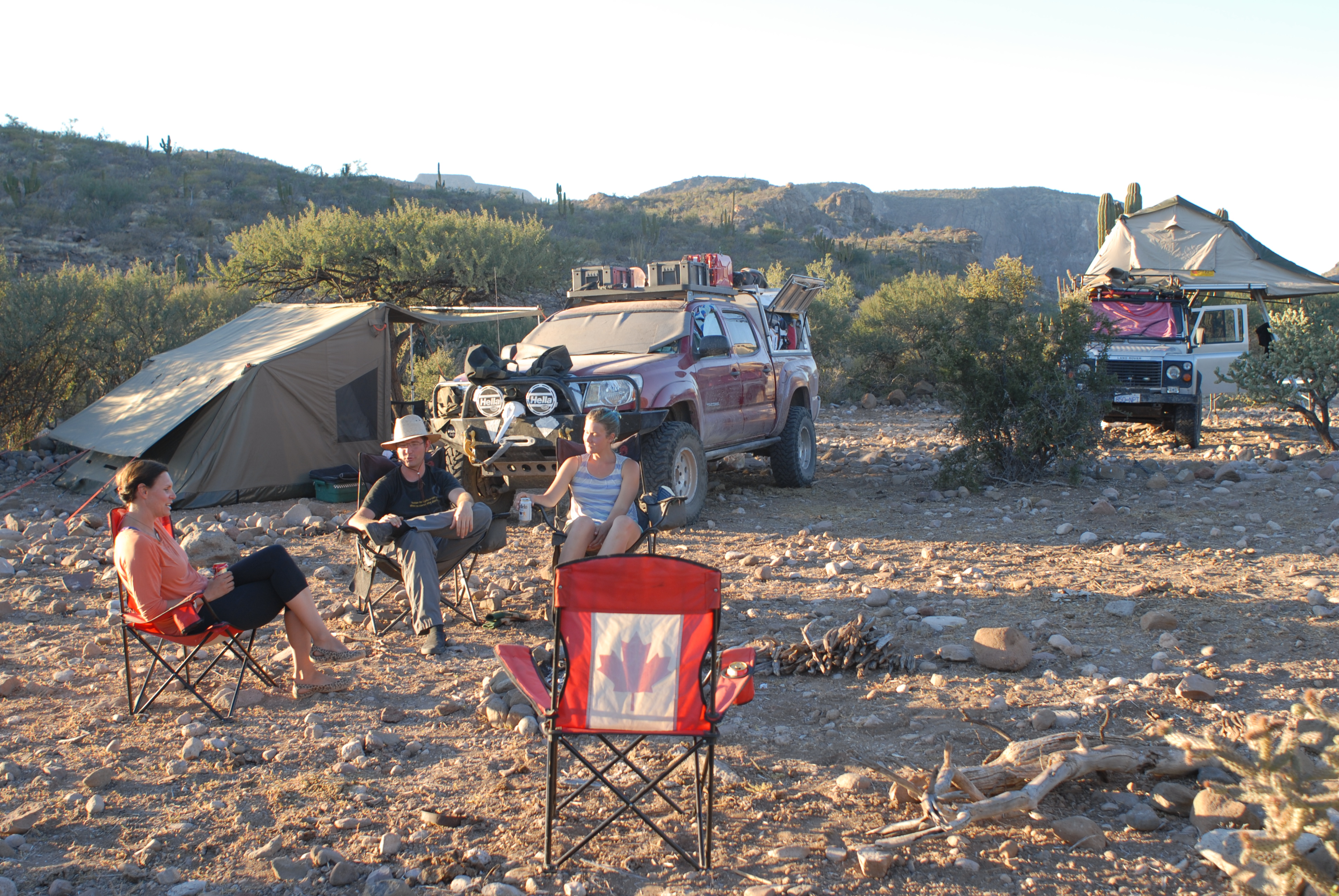
As a last act, we loaded Rivets up with two extra “just in case” jerry cans of gas for Red Beauty (I would publish the range that Rivets has thanks to its parsimonious and efficient little diesel engine, but the number embarrasses me) and made our way south out of town.
Our first turn was left off Mexico 1 onto a dirt road that led through a dusty plain and then up into the mountains, it was signed, and both Ashek and I sailed right past it. While this sounds like foreshadowing, it isn’t, because it was the last turn we missed in over 200 miles of serious backcountry travel, and it is a huge tip of the cap to Ashek that we didn’t waste a drop of gas or a minute of time thanks to a wrong turn.
***
Mother of God, it beautiful in the mountains, but it was hot. Hot in a way that we had yet to experience on the peninsula, and it was a roasting, dry heat that reminded all of us how unpleasant it would be to perish from lack of water.
We stopped for lunch beside an smallish oasis that had been dammed up, but the proximity to water did nothing to diminish the heat and we raced through our food if only to get back in the vehicles to keep moving and create airflow over our bodies.
I gave Leonie the thermometer we keep in the back of the truck and snapped a picture of her holding it. No lies there, 110 degrees.

Sweltering, thy name is Baja.
***
What a drive. What began as a relatively easy, if not dusty, traverse on a dirt and gravel road where the only real issue was ruts and washboard, began to change as we worked our way into the Cerros Blancos, weaving through what we think was the La Presa arroyo, where dry wash would be replaced every few kilometers with apparently spring-fed pools, around which we saw small ranches and livestock pens. Goats and chickens eyed us with suspicion, and the ranchers waved to us with broad smiles from the backs of their rugged looking burros.

Challenges included terrain, rocks, cactus, and cows.
We kept moving east and then north, the road replaced by pebble roadways in the dry river bed (in places, narrow enough that there was barely enough clearance for the sidewalls of my tires) and ruts up the hills and across the mesa tops. Cardons, chollas, palo verdes, and what appeared to be some species of elephant tree appeared, and groves of ocotillos showed themselves on the hillsides.
We had been in the vehicles for maybe 6 hours, the girls were doing just a remarkable job of keeping themselves entertained, when we finally traded the ruts in the mountain roadway we were on for something that was less a road than it was a place where there were fewer cactus in our way. There were no signs of vehicle tracks, and the sand between the rocks betrayed the real commuters here: cattle, goats, and coyotes.
Ashek scouted ahead on foot to locate a potential campsite and we found a clearing down a burro trail that itself was roughly 7/8 as wide as the truck.
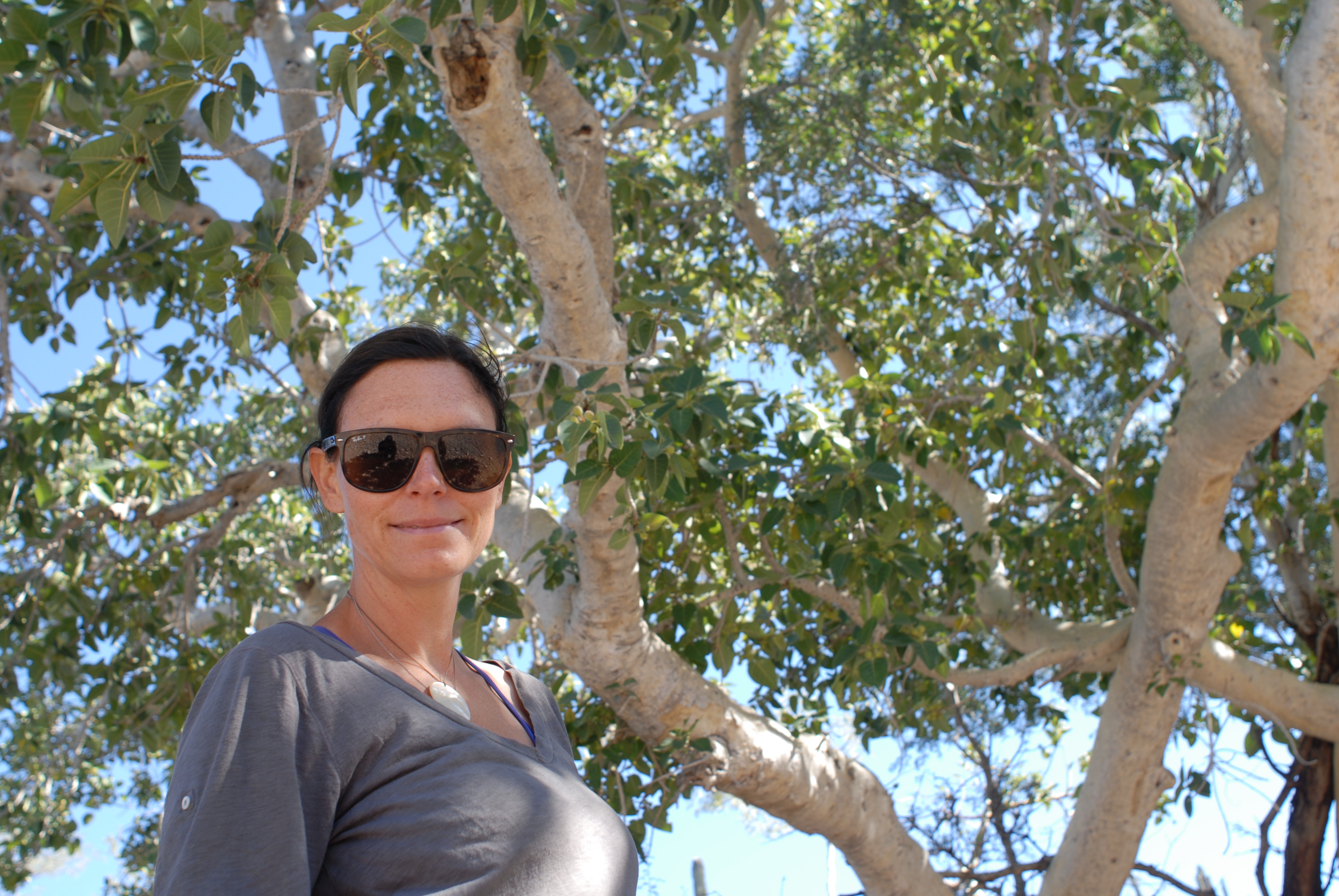
Great looking fig tree, seen here sheltering a great looking wife.
We made it in, found a lovely clearing beside a tinaja and an enormous and clearly ancient fig tree, and began clearing away rocks to establish a camp. While we didn’t really know if we’d be able to find Los Dolores or these rumored hot springs, we had an exquisite campsite in the mountain desert, which Val and I had not enjoyed since camping outside Catavina with Feral and Stephanie.
Poolside on the high mesa.
The tents went up, we wolfed down an enormous dinner, and sipped on cold cans of beer while the stars came out and we planned our hike off this mesa to locate Los Dolores.
***
“So the good news is that I think I found the ruins of the mission” announced Ashek, reappearing in camp as I sipped on my coffee the next morning.
“That’s great!”
“Yeah. Here’s the thing: it’s roughly a three hundred meter sheer drop off the face of a cliff to get there.”
“Ah.”
***
Ashek was not kidding, as further exploration would prove. We were camped a few hundred feet from the wall of a canyon, the edge of which plummeted straight down from three to five hundred meters, depending on how one read the topo map.

This is what it looks like at the edge of the mesa – basically, straight down for a thousand feet or so…
We settled on a plan to skirt the southern edge of this canyon in an effort to locate a trail that appeared to lead down into the valley somehow, at which point we could follow the wash toward the ocean and intersect with the ruins and a grove of trees that was far too symmetrical to be anything but man-made.
Backpacks loaded, the girls fully kitted out, we set off for what we assumed would be a challenging hike (even for us) but, as ever, ready to turn back in the event that circumstances overwhelmed us.
We essentially bushwhacked our way around the canyon rim, which, because everything in the desert is sharp, thorned, pointy, barbed, or spiked, was slow and cautious going. And, not for nothing, hot. After almost two hours, we made our way to a break in the cliff that signaled our opportunity to descent, and threaded our way downhill.
Weaving along a burro path that we hoped was more or less going the right way we heard some noise coming from the brush and presently a vaquero on a rugged white burro emerged, looking at us like we were nuts.
Val interceded on behalf of the team, and explained we were camping on the high mesa and hoping to see the ruins. The vaquero graciously explained how to get to the ruins of Los Dolores, and then, looking at the girls, spent another ten minutes cataloguing the dangers of the trail (hills, cactus, very difficult).
And, shortly, he was off, and we were all envious of his sure-footed mount that had him disappearing over a ridge in minutes, suspended well above the ankle-grabbing terrors of the vegetation alongside the trail.
By noon, we had made it to the break in the canyon wall that would take us down to the ruins, but were famished and sat down to lunch. Ashek once again scouted ahead and came back to the lunch spot.
“So the good news is that I found the trail down off the cliffs.”
“Great!”
“Yeah, except it is a little steep.”
***
It was a little steep. So steep, in fact, that a series of dramatic switchbacks had been carved into the wall to aid people and animals on the way down, and we spaced ourselves out to make sure that any unfortunate tumbles were not further compounded by having multiple participants.
By the time we picked our way to the bottom, Sylvie was bushed, and so I stayed with her on a large volcanic boulder while she rested up as the rest of the group, lured by the gravitational pull of the palm trees below us in the valley, moved ahead.
Sylvie and I chatted a little while I pulled off her boots and rubbed her feet. I was in the process of explaining to her that we should head back because we had hours of uphill hiking through the tangled desert ahead of us, when her eyes narrowed and she looked at me and said “Dad, I didn’t come all the way out here just to walk back home.”
I couldn’t talk her out of pushing on.
So, on went the boots and she gamely soldiered forward, and on one section of the trail bumped into Val and Leonie. They had made it to the initial springs, which appeared to have been dammed up and trapped into some kind of agricultural cistern, and had run out of gas and were headed back to camp while Ashek and Alex wanted to forge ahead to the ruins.
Sylvie, however, refused to turn back until she had at least touched a palm tree, so we moved forward. Finally, we made it to what had clearly once been the springs. Industrial equipment had been used to dam them for use at a ranch at the mouth of the canyon, and so against a backdrop of palm trees, a mound of earth and two large control valves were all that remained.
The SilverFish was disconsolate, and couldn’t believe she had been robbed of the swim in the springs she had promised herself over and over for the past four hours of torturous hiking. She put on a brave face and made me snap her picture, with palm trees behind her, but beneath the mask was a weeping five year old.

And then, we had an uphill battle for the entire trip home.
We began to pick our way back up the trail, picking up Val and Leonie at one point, and incredibly, Sylvie got stronger and stronger. This was a relief, because the trail was too steep and technical at the cliff face for me to even think about carrying her, but she and Leonie scrambled up like little goats and, as we caught our collective breath after an hour of climbing at the top, Alex and Ashek appeared.
We learned that they had found the ruins, which had been fenced in and gated off, and further the grove of trees which we had spotted from the high mesa was also surrounded with fences.
The expedition to Los Dolores was, after all this work, in the a strict sense of the word a bust – time and civilization had finally caught up with her, and she had fallen victim to ranching, water rights, and right of way issues. There would be no bathing in century-old granite pools, no harvesting figs or mangoes from undiscovered orchards, no sunbathing on prayer benches hewn from the local stone.
So, home we went, fanning out as we worked our way through the trail-free rim of the canyon, letting the girls pick their way back to the tinaja where our camp was located, and trying as hard as we could to avoid the dozens of species of cactus that waited to shred our clothing, or our flesh.
I became tired, and Sylvie, maddeningly, came alive. She was chirping away, planning a cactus garden that she wanted to grow on the roof of our apartment in Brooklyn, wondering what kind of cactus we should take home, what was for dinner, what her sixth birthday party would be like, what her favorite Monster High doll was, and whether or not I had remembered that she really likes pears, because to be clear, she really likes pears.
And, after a seven hour marathon of nothing but vertical ascents and descents fringed with cacti, suddenly, we made it back to camp.


All of us flopped into our chairs, overjoyed to no longer be moving, and pulled off our boots and drank water and then opened cold cans of beer (adults) and cold boxes of apple juice (bugs).
We made a fire, and watched the stars, and the girls taught Alex and Ashek how to make “spiders” (hot dogs, grilled over a fire, with the ends cut so they splay open as they heat up) and we talked about what we should do next, and how long we might stay in the mountains, and importantly, how little we were going to do the next day.
We were all happy, and exhausted, and with full bellies and the sky as full of stars as any of us could imagine, and the temperature dropping enough to make us comfortable in our sweaters, and we all agreed that this expedition was the best failure any of us had enjoyed in a long while.
***
After a couple days we left the high mesa campsite and worked our way east through the mountains to San Evaristo, which was as remarkable a drive as advertised – for the most part, we felt as though we were winding our way through our own private version of the grand canyon – and found ourselves spit out, after some nail-biting climbs and switchbacks and shelf roads onto the shores of the Sea of Cortez, and another hour or so later were camped on an unmanned beach, just us, floating in the water and allowing the accumulated dust and the grime of the mountains wash away.
We decided we’d stay together until we had all celebrated Sylvie’s birthday, and then, now that we were on a coastal road and just three hours or so north of La Paz (and thus, out of the danger zone that made traveling together sensible, if not critical, through the interior), return to our individual agendas.
But the trip to Los Dolores was a great one, and everything about it crystalized in our minds what a luxury it was to be traveling in a mode where you can have a map spread out in front of you, on the hood of a truck, and point to a spot in as inaccessible a place as you can imagine, instruct the girls to fasten their seat belts and, after a lot of work, get there.
And it also made clear how lucky we have been to bump into like minded-travelers in Alex and Ashek, who are not only unafraid of bad roads and questionable terrain, but aren’t afraid to partner up with a family with young kids.
A lot of people would look at the girls and see a burden, an unnecessary encumbrance to this kind of journey. We don’t, but then again, we don’t really have a choice.
It’s great to have found a couple of people who, without any kind of inherent bias, see two girls and don’t see any limitations at all.
